After picking up some last minute things (Christina sent an email asking for some Pisco) I headed to the airport to make my way home. The check in line took about an hour and a half to go though, but once I was checked in I made my way to the plane only to find out that my seat was directly in front of the exit row, and therefore I would not be able to put my seat back. This made for a very long sleepless night, but as I was quite excited to get home for a while, I was wide awake when I made it to Newark early in the morning.
My time in Newark was short lived. As the plane arrived about 25 minutes late, I had only 40 minutes to go through the boarder checks, security and make it to my flight. Every person wearing a Continental uniform I asked if I had enough time to make my flight, and each one looked at their watch and said no, but I should give it a shot. As I was rather rushed and flustered, when I made it to customs, with what looked like a pipe bomb on the side of my backpack, they asked quite a few questions about what I was carrying, what was in my bag, how much was in my bag and most importantly, how could I have such a heavy second bag that was just filled with souvenirs (they obviously haven’t been to Ecuador where the hammocks are so comfortable and cheep that you have to buy at least two of them). After he let me through, I tossed my bags on the conveyer belt and ran as fast as I could to the airplane. Luckily I made it in time, and surprisingly my bags made it to the plane before I did.
My flight from Newark to Halifax was much more pleasant as there were very few people on the plane so I could sit wherever I wanted and stretch out. We were very fortunate to have clear skies and were able to fly directly over Manhattan Island (with the flight attendant pointing out all the sites), Boston and then directly up the centre of Nova Scotia. It was so clear you could see both sides of the province and make out everything, including Chester and South Shore Marine.
As with every time I come home, I try to do something different to “shock” my parents a bit, but it doesn’t work anymore. This time I decided to get off the plane with the brightest orange felt hat I could find. Well, I didn’t think it was that unusual of me to do something like this, but when I got off the plane I came out and saw Mom look at me, turn around and walk to the other end of the airport, obviously not recognizing me. I guess after 4 months in South America, not even my family knows who I am (but luckily she did acknowledge me once I caught up to her at the other end of the airport).
That night it was good to be home in my own bed, speak English to everyone I saw, know that I can eat everything laid out in front of me, and throw the toilet paper in the toilet. The past four months had been one of the most incredible experiences in my life and definitely not something I will ever forget. All I need now are a couple of trees to string my hammock between, lie back, sort through my thousands of pictures and remember the good times, good friends and wonderful memories that will last a lifetime.
Tuesday, June 3, 2008
Monday, June 2, 2008
Jun. 1 – 2 – One last time in Lima
My bus arrived mid morning and my cab driver took me to a hostel he knew about, and since I didn’t sleep a wink I was more than happy to have the driver select a hostel for me (but when he tired to convince the front desk staff that I was willing to pay at least twice as much for the room I decided I should take care and notice what was going on). Once I got settled I went out on the town to get a few things done before I came home including get a haircut, buy a few last minute souvenirs.
One of my stops was taking doing some art shopping. After my conversation in Cusco, I decided I needed another piece of art as my quintessential souvenir from South America and headed to the artisan alley in Lima. After poking around a dozen or so art shops, I managed to find the perfect piece of art which they packed for me in a piece of PVC pipe. Needless to say, it looked like a pipe bomb, so I was a little nervous going through the airports with it later.
As I had spent much time in Lima, there wasn’t much for me to do there, so I spent most of my time left in South America relaxing at Larcomar and at various places in Miraflores that I enjoyed reading and relaxing before my flight (there was lots of fog and quite cold so I didn’t head down to the beach as planned). The one thing I did do that I hadn’t made time for before was head to the Museo de Oro del Perú. This museum was one of the must see attractions in Lima, but in 2001 there was a story that over 80% of the artifacts were fakes. Needless to say, this destroyed the reputation of the museum which was filled with the largest collection of gold artifacts in Peru. Since then they have cleaned up their exhibition and have reopened.
When you go into the Museo de Oro, you head down to the basement to view the artifacts, which are all located within the massive underground vault. There are rooms filled with thousands of artifacts made of gold, silver, bronze and clay from all the various South American cultures. There is even a room dedicated to only cups, there’s that much stuff. As they had problems in the past regarding reproductions, some of the items are labeled as reproductions and the wax figures dressed in the traditional costumes of different tribes are labeled as being representations. That doesn’t mean they don’t have a mummy room complete with four mummified remaines and the various items found in their graves (including cone shaped sculls and a poncho made of gold).
The ground floor of the museum, though not as interesting or filled with historical significance, is astonishing. This part of the museum is known as the Museo de Armas, and holds the world’s largest collection of weapons. There are at least 10 massive rooms where the walls, tables, shelves, drawers, ceiling and every nook and cranny are filled with every imaginable type of weapon. They have a whole room dedicated to Japanese weaponry, swards filling four rooms, every kind of gun known to man (in some display cases the guns are two or three deep) and helmets from every army to ever fight. When you look at a room you think you saw everything, only to notice that stuck under the table, beside your feet, is another shelf filled with more guns or swards, or brass knuckles. It reminds you of an old book store where there are books everywhere you look, but instead of books they are weapons.
Saturday, May 31, 2008
May 28 - 31 - Where the condors fly
The bus ride to Arequipa was a lot longer than I expected. I should have known though. Lonely Plant had been wrong about the times of every other bus ride I had taken, so it would go without saying that today’s bus ride would be exactly as long as they said. So, needless to say, I didn’t arrive in Arequipa until late in the evening and had to take the first room I found. Even though the price was a little more than I was used to, the hotel was probably one of the cutest ones I have stayed in since leaving. It was a small collection of rooms scattered throughout a collection of alleyways, all painted bright colours. But that was not the highlight of the night. After checking in I headed over to a restaurant highly recommended by Manuel. This East Indian themed restaurant had probably the best mean I have had in my life….a lovely alpaca meat with a coconut milk sauce…delicious (Turk II if anyone wants to go check it out).
The next morning I was forced to change hotels and spend most of the morning taking care of business to prepare my trip to the Cañón del Colca and the rest of my plans for Arequipa. I also got to walk around the town a bit while I searched for everything. Arequipa, like Sucre, is all painted white and filled with small, narrow streets. Interestingly enough, each block actually has a few entrances into the interior maze of courtyards and alleyways. So, within each of the blocks is a small community itself with different homes, courtyards and streets all contained within a few different entrances.
After I got everything organized I decided to visit the Museo Santury, a museum that was recommended by every traveler I met. Even though the museum (associated with the Universidad Católica de Santa Maria) didn’t have very much to offer in terms of artifacts, it did have quite a large display on Juanita, known as the “Ice Princess”. The Inca culture was not known for sacrificing people, but Juanita was one of the very few bodies that have been found sacrificed to the gods. The archeologists have concluded that the only times the Incas sacrificed humans was to appease the gods in the event of natural disasters. In the case of Juanita, she was a 12 year old girl that was raised in Cusco to be a sacrifice to stop an erupting volcano. As she was raised to be a sacrifice, she was treated with the utmost respect and treated like royalty through her life before her walk from Cusco to Arequipa that undoubtedly took months.
The artifacts the Museo Santury displays are those found from the burial site near the summit of Nevado Ampato. As the land was frozen at that altitude, Juanita and all her artifacts stayed frozen for hundreds of years so they could be easily studied by archeologists. Of particular interest to the archeologists was Juanita herself, who was preserved very well in the frozen tundra and is still on display in the museum in a specially built glass freezer in a back room of the museum. It is kind of eerie standing there looking at a frozen woman through the glass, but probably not as shocking as the people who discovered her when they were out for a walk and tripped over her.
The rest of the day I spent relaxing around the city, in particular at the Cusco Coffee Company (Finally a good cup of South American coffee, it just took a while) reading a book and enjoying my last couple of days in South America. I also spent a fair amount of time in the Plaza de Armas. This plaza was probably one of the most beautiful main squares I visited in South America. It has probably one of the longest churches in the world on one side of the plaza and then the others have matching buildings with a terrace on the second floor filled with small restaurants catering to the tourists, but still a lovely place to have a drink and watch the world go by I the plaza below.
The next day I headed off to the Cañón del Colca very early in the morning, or late at night, I’m not sure. All I know is I got up at 1:30 to catch the bus at 2am (which in true South American style was obviously half an hour late), but it gave me enough time to catch a late night snack with all the bar goers who were heading home. I tried to sleep in the bus as it made its way to Chivay, but with no luck. Once we arrived in Chivay we had a very small breakfast to start the day before making our way to the Cruz del Cóndor where we would watch the condors fly.
On the way we stopped at a couple of different towns to check out a market and small church, all of which, though interesting, did not live up to the standards of some of the other things I had seen throughout my travels. But once we made it to the Cruz del Cóndor we were able to see the birds we got up so early in the morning to see. The Cruz del Cóndor is located in the middle of the canyon at a high point on the cliff where there is lots of room below where the condors can live and fly and where it is quite narrow so the birds are close enough to see them. After 2 hours of waiting for the condors to arrive and start their flight, but the wait was well worth it. These large majestic birds were flying so close you could almost touch them. They were so close I could take pictures as they soared above and below me.
As we made our way back through the Cañón del Colca, we were able to see why the Cruz del Cóndor was such an important lookout point: everywhere else the condors were much to high for you to even make out what kind of bird they were. But the drive back through the canyon provided a different level of excitement as we drove through many different types of terrain within the same canyon. By the Cruz del Cóndor we were close to many high cliffs, an area that goes as deep as 3,000m, making the Cañón del Colca the second deepest canyon in the world (the deepest is around 100km to the North-West). But as we made our way back to Chivay we drove through the agricultural landscape that has survived from the pre-Inca times. Because of the steep cliffs in this canyon, the farmers were forced to terrace the entire valley. This terraced landscape was more extensive than anything I had seen before where the agricultural production was limited to only a small portion of the hill, but in this valley, every square inch was being farmed. When you looked down upon the valley it looked like a 3D representation of a topographical map with the contour lines easily recognized. The ability to see these contour lines created some of the most amazing patterns in the valley, but due to the haze of the day, it was impossible to get a good picture of them.
Before heading back to Arequipa, we stopped in Chivay for lunch and a wander around town. Unlike most of the other places I had visited, this tourist town’s market didn’t cater to the tourists at all. Instead, as the capital of the region, it catered more to the local people’s needs, thus creating a more unique market experience. It’s alleys between the stalls were very narrow, and the stalls were some of the smallest I have seen, with everyone concentrating on some need of the locals, from toys for the kids, to pots to clothes, with the food located in another market. There were very few, if any, craft/tourist shops, very refreshing after visiting hundreds of them over the past four months.
The drive from Chivay to Arequipa was slightly more interesting than at 2:00 in the morning, especially since we were able to see some of the landscape, but by this time I had seen enough of the mountainous landscape that it had lost most of it’s interest, especially since I had seen more vibrant landscapes in other parts of South America. The one highlight though was stopping to see the vacuñas, a cousin to the llamas and alpacas. This wild animal provides the softest wool and is among the rarest Andean camel, especially since people have yet to find a way to domesticate them. This makes the wool very sought after and valuable, thus a lucrative business for those who are able to harvest the wool (which is made even more difficult since they are a protected animal). A vacuña wool scarf would cost upwards of $200 in the market, while a baby alpaca scarf (next softest wool) would cost around $8.
The next day was my final day in Arequipa, and practically my last day of travelling since everywhere I was to go from here I had been before. Needless to say, after the long day I had the day before, I didn’t have much energy and spent most of the morning drinking coffee at Cusco Coffee and relaxing around the Plaza de Armas, which suited me just fine since the only thing I had to do before my bus at 9:00 that night was visit the Monasterio de Santa Catalina.
Everyone who visited Arequipa has told me to spend lots of time at the Monasterio de Santa Catalina, and it did not disappoint (this is my official recommendation to visit it if you are ever in Arequipa….definitely one of the coolest places I visited in my whole time in South America). Founded in 1580, the Monasterio de Santa Catalina was an incredibly rich colonial convent which required a substantial dowry paid to the convent in order to have your daughter considered to be a nun there. Because of the high dowry required, only the elite of Spanish families were able to send their daughters there to live as a nun, but the money raised through this requirement provided a lifestyle more like that of a socialite than of a nun. After their mandatory time in solitary confinement that the nuns went through to join the convent, they were catered to by up to four servants (more like slaves) who took care of their every desire. They would eat the best food, have large homes to live in and hold the social events of the city within their walls, inviting musicians to play almost constantly. They were living it up as if they had never left Spain. But after a few hundred years of this, the Pope got wind of what was happening in Arequipa and send a very strict nun to straighten things out. When she arrived she put a stop to all the festivities and turned it into one of the strictest convents in all of South America, and the substantial dowries were sent back to Rome.
Because of all this money available to the convent, they have created one of the most impressive sites in all of Arequipa to visit. Covering an entire city block, the convent has only a few entrances, but once inside the compound the alleys were lined with flowers, brightly colored buildings and more courtyards than you can imagine. Its beauty is so renowned that it is a popular stop for photographers around the world and while I was there was being visited by a group of photographers travelling around Peru. It made for some great opportunities for photos as the other photographers were conscious of the need for clear shots and moved out of the way whenever you wanted to take a picture. This is the first time I have ever had the experience of everyone moving out of the way of my picture without my asking.
After a few hours of walking around the streets of the convent (it’s that large and breathtaking) I spent the rest of the afternoon relaxing around Arequipa absorbing the last little bit of the Andean culture before boarding my overnight bus to Lima (I think it should be noted here that the departure lounge for Cruz del Sur in Arequipa would rival any executive class lounge for the top airlines at any airport in the world….talk about gorgeous….and a refreshing break from some of the dirtiest bus stations I will ever see in my life).
Tuesday, May 27, 2008
May 25 - 27 - I think I can, I think I can, I think I can……
Last night was the last night we spent together as the full Bolivia ’08 GAP group, so needless to say, we were a little tired in the morning. After our flight to La Paz, none of us had much energy and it took almost the rest of the day to have lunch (for all we know, it might have only taken about 15 minutes, but we were a little slow). The rest of the day I spent getting ready for my trip I mentioned I booked last week; climbing Huayna Potosí.
Huayna Potosí is one of the large mountains around La Paz, and is viewed as one of the easier climbs in Bolivia where they claim people who are fit can do the climb. At 6,088m it passes the “magical” 6,000m mark, but is sadly 26 feet short of the equally magical 20,000 feet mark. At this altitude, they recommend that you take at least two days to climb, and if you have never done anything like this or worked on glacial ice and cliffs, spend another day training. When I booked, no one told me about the cliffs, so when I said I was from Canada, they didn’t figure I needed any training on how to walk on ice….I didn’t argue.
Before I left for base camp, I had to get a bit of equipment in La Paz. The company I signed up with, Travel Tracks, supplied most of the equipment including crampons, parka, warm hats, mittens and winter pants. The one thing they didn’t have were boots for me. As I have explained many times over, nothing is built for me in this country. I tried on at least 20 pairs of boots in two different rental shops before I found something that fit me. Even then they were quite snug. As I sat in a chair they kept looking along the shelves pulling off boots they though might be larger than what the chart said was the largest pair in the store. Each time, they didn’t fit. It wasn’t until someone suggested we just try on the insoles, to speed the process along, that we figured out the largest pair of boots didn’t fit me because someone had switched the insoles on us. Once they were put back together I had no problems at all and was ready to go.
After a farewell dinner with those who flew with me to La Paz to end the trip, I got into bed quite early to make sure I was fully rested for my upcoming climb. I had to depart at 9:00 in the morning from the Travel Tracks office and took a taxi to the trail head where I would start my climb at Paso Zongo (4,700m). At the trail head I was supposed to meet up with the girls that would participate on the climb with me, but sadly one girl in the group was forced to return to La Paz due to altitude sickness and the others had gone ahead. Once we all got squared away, Pasqual (the cook), Fritz (my guide) and I headed on our way up Huayna Potosí.
The beginning of the walk was very simple and not too strenuous, but it wasn’t what I pictured a hike through the mountains would be, especially since we started with a quick trip across a dam and then walked on top of a pipeline before turning off to the actual trail. From that point onwards it was practically straight up. As this mountain is considered an easy hike, it didn’t take too much effort on my part for the first part of the climb and we caught up to the girls in our group very quickly. Before we met up with the girls, Pasqual kept informing me that they were a couple of beautiful women and I would really enjoy climbing with them. Once we met up with them (keep in mind the girls didn’t speak Spanish, and Pasqual and Fritz only spoke Spanish) he was very quick to find out if I thought they were beautiful as well. From that point on, Pasqual and I had bonded and the topic of conversations only went downhill from there, but it was enough to keep my mind off of this mountain that seamed to only get larger as I walked onwards.
Before we stopped for lunch, we hit the first wall of our hike. There were two options to get past this wall, one that they told me about, and the other I didn’t find out about until I reached the top of the wall. With my walking poles on my wrists, my massive 25kg backpack on my back (I had to carry all my winter clothes, safety gear and boots for my final climb tomorrow) I had to scale a vertical wall with minimal foot and hand holds. There was nothing like climbing up a rock face without any safety lines with the weight of my backpack trying to pull me off the cliff. I defiantly harassed Pasqual and Fritz a lot when I got to the top and noticed that the black rocks had been warn brown from the traffic of the main trail, the one that everyone else appeared to climb on their way up the mountain, or at least the one that everyone passed us on the trail used.
After a quick lunch, we headed off for the final hour of the climb up to Campamento Rocas (5,200m….about the same altitude as Everest Base Camp), the refuge where we were to spend the night, and the base camp for the climb to the top. The last part of the climb up to the refugio was a very easy climb and didn’t take more than an hour. The rest of the day and evening was spent lounging around and chatting with the other climbers. The two groups that stood out among the rest (about 10 climbers in total, along with their support staff) was a couple from Colorado who were there to climb their fifth mountain of their trip to Bolivia, and a man from Denmark who was practicing on Huayna Potosí before he brought a group of tourists from Europe to climb later in the summer (he also had climbed Kilimanjaro four times and was probably the most experienced climber on the mountain…aside from the guides that would climb Huayna Potosí twice a week).
After an afternoon of socializing, we headed off to bed around 6:00 as I had to get up extremely early in the morning to start my climb at 2. As it was going to be cold that evening (they figured it would get down to 25 below before the wind chill) I piled everything I was going to wear into my sleeping bag to keep it warm for when I put it on in the morning. It wasn’t until I got up at 1:30 to get ready for my climb that I realized that I didn’t put my iPod or headlamp in my sleeping bag, and the extreme cold zapped all the energy out of the batteries so I had neither my iPod to entertain me, or my headlamp to guide me for the night time climb. Luckily there was a full moon out that night so I didn’t have to worry about the headlamp guiding my way, but the lack of iPod meant I would be singing the same song over and over again in my head (because of the altitude, the air is so thin that you can get out of breath simply by talking, let alone walking…so an iPod was recommended to entertain me for the 8 hour climb ahead of me).
Needless to say, without my light or music, I put on all my clothes (practically everything I owned and rented from Travel Tracks including two hats to make sure I was warm enough) and headed out to the glacier to put on my crampons and begin my hike. Over breakfast I talked to Pasqual and Fritz about the climb ahead and they both were convinced that I would make it to the top since I had no problem with the hike the day before. All I would have to do is take my time and I’d be there in time for the sunrise. So off Fritz and I headed at an extremely slow pace (for sea level) and started the climb.
The first incline was one of the steeper parts of the climb and we made it up that with very little problem (and passed the girls who left an hour ahead of me on this incline). What made it easier, and helped me set my pace and stride, was the fact that it was such a well traveled trail so there were footsteps already in the snow that I used to help control my assent. My experience was a very unique one in comparison to everyone else as I did everything by the moonlight, which cast an eerie glow over the snow and mountains around, which I had to stop and gaze upon a couple times an hour (or at least that’s the excuse I used for why I stopped to take a break to catch my breath from the lack of oxygen).
The path we followed went up from the refugio and curved to the right around crevasses before turning back towards the summit as you wove your way between two peaks to reach Campo Argentino (5,500m), which we arrived at 1.5 hours into the climb. Campo Argentino is a plateau at the base of the final peak from where we were able to catch a glimpse of La Paz in the distance, a glowing oasis about 25km off in the distance. Also at this point we were also able to make out all the other climbers on the hill, which were easy to spot by the glow of their headlamps. The walk around Campo Argentino took about one hour before we reached the point where we would step over the edge to start our climb of the Polish Ridge. Up until that point I had no worries about my abilities reaching the top, but once I looked at this ridge all I could think was “Oh Dear God” as when you looked down you knew it was steep enough that if you fell, you would tumble all the way to the Amazon jungle before you stopped tumbling. It was also at this time I started to feel a headache from the altitude.
The climb up the Polish Ridge was a fairly dangerous one and took a lot longer than you would expect when looking at it. Because the air was getting quite thin I was forced to stop every 10 steps, not because I was tired, but because I was out of breath. The interesting thing was that once you stopped it only took you a few seconds to catch your breath because you weren’t tired because the climb was hard, it was because you couldn’t get enough oxygen to keep your muscles moving. After about an hour and a half I finally made it to the top of Polish Ridge and entered a level part that was a welcome break to the constant step upwards. It wasn’t until I reached the next incline that I began to falter. When I started the last 300m of the climb I hit a brick wall and started to feel sever stomach pain and headache. Felix was extremely supportive and felt that if I could work through it I would make it to the top, but after trying to climb further three times I decided that 5,760m was my point to turn around. Even though I didn’t make it to the top of Huayna Potosí I was extremely proud of what I had accomplished and how far I had made it, especially since I had crossed the 5,000m mark I had set before I came down to South America, and was only 300m from the top of the mountain….an incredible accomplishment.
The descent was much faster than the climb up, but it was much harder for me because of the stomach pains I was feeling just got worse as I went down (I now think that it wasn’t the altitude that gave me the problems, but over exertion that stopped my climb since altitude sickness improves as you descend, and mine only got worse). I was extremely tired and weak as I made my way back to the refugio and had to take more breaks as every step was painful. By the time I reached the hut I made my way upstairs to crumple in my sleeping bag and hopefully sleep it off, but with no luck. I was abruptly awoken when I had to quickly run outside because the nausea got to be too much. It was at that time that everyone told me that no matter what I had to get lower because the altitude sickness would just get worse until I got to lower ground.
Surprisingly, the descent from base camp to the trail head was the hardest part of my climb. The sickness only got worse as I went down and I had to stop every few minutes to gather the energy to carry on. It wasn’t until I reached the trail head and was getting into the taxi that I began to feel better, but that was mostly because I finally decided to eat some food, and as soon as the juice hit my stomach I started to feel better, but unfortunately I wasn’t myself by the time I made it to La Paz and decided to just stay in my hotel room for the evening (except for a quick run out to get some food) and sleep.
The next morning marked my last day in La Paz, which was actually a very good thing since I hurt my knee on Huayna Potosí and everything in La Paz is up and down. So most of my day was spent buying all the textile souviners I had been looking at over the past couple of months and visiting the Coca Museum. This museum is a one of a kind museum that looks at the history of the coca leaves and cocaine, but puts a very positive, pro-coca spin on the entire drug war and promoted all the benefits of the coca leaf and cocaine. Throughout the day I made my last visits to all the restaurants and coffee shops I got to know in La Paz before heading to my hotel for the early morning departure to Arequipa the next day.
Saturday, May 24, 2008
May 21 – 24 – The real capital
Luckily for Chris, our cab driver was quite fast, and the roads were perfect, so we made it to Sucre on time for the game, and they found the bar only a few minutes after the game started. As Chris is a diehard Manchester fan, we all opted to cheer for Chelsea, and I did my best as a good Canadian to point out that hockey was a much better game, and every little thing that the fans groaned about would never happen in a hockey game (come on, how many hockey players take a dive…..and the net is the size of the goaltender and they can get the puck in there at least 4 times a game…not like this silly soccer stuff). As we enjoyed this bar so much, and we were looking for any reason to sit still for a while, we set up camp there for most of the day, only taking a break late afternoon to go to the hotel for a shower and nap before returning for dinner and a night of hanging out. During the evening, we had a few different presentations from different tour operators outlining the different options we had in Sucre over the next couple of days. As tomorrow was Corpus Christi, nothing would be open so we opted to go on a biking trip in the morning that would take us on a downhill route to the dinosaur park….that is if the tour group would delay the start time to 11:00 so we could sleep in.
Well, true to their word, the tour group did delay the start time, and even though they had an extra two hours, we still had to wait a little bit while they found bikes for all of us and loaded the trucks with all the equipment. Once we piled in, we headed up to the highest point on the road to start our downhill trek and unloaded beside a cement factory. While the drivers were unloading the equipment, our guide took us for a walk up the hill behind the cement factory along a gated gravel road. After a short walk along this uninviting road we came upon the Parque Cretácico, an brand new, beautiful looking, Disney-esque dinosaur park. This park, the main children’s attraction in Sucre, was built around the largest set of dinosaur tracks in the world. About 25 years ago, the workers at the FRANCESA cement company noticed that there were a series of indentations in the hillside that were to ordered to result from the mining. After some investigation (which took a few years before anyone came down to look into it) it was determined these were indeed dinosaur tracks, over 150 sets of tracks (6,000 tracks in total) up to 80cm wide coming from many different types of dinosaurs.
They figure these tracks were formed when the dinosaurs came to the water’s edge to drink. At the time this area was tropical and close to sea level, so when the dinosaurs walked to the water’s edge their tracks were left behind in the mud. These then dried and were covered by other dirt and new tracks were set in the mud. In all, they have found about 8 different layers of tracks which were formed only a few days or weeks apart from each other. After they had fossilized, the tectonic plates started moving in order to create the Andes and thus moved the once level land, onto a 90˚ angle creating the most intriguing way to look at dinosaur tracks. Recently declared a UNESCO site, they finally have money to protect the tracks (which, exposed to the elements, have been deteriorating at an astonishing rate) but since the area is so large, a shelter is not an option, so instead they are covering the hill and tracks with latex.
After looking at the wall, you go for a walk through the dinosaur park, consisting of life-size replicas of what the animals that made the tracks looked like. These were probably the most anatomically correct dinosaurs in the world as they have not been given the “Ken doll” (in other words, reproductive and digestive organs were not omitted, as is the norm). It made for a very Disney type of park in the middle of Bolivia.
Once we returned to the bikes we realized that we were not going to be starting at the park, but instead would drive another 15-20 minutes to the top of the next hill where we would start (some of us didn’t want to do any uphill biking). Once we got there and unloaded the bikes, they noticed that there were not enough helmets, so one of us would not be able to go. We also noticed that the bikes were not in the best condition possible, with the seat on my first bike not able to raise, and the second bike I had didn’t have top gears, so my speed was greatly reduced. Sadly, the trip disappointed further, probably because I did the death road in La Paz. The downhill segments weren’t as quick or steep, and the total length of time was so short that when we got to the bottom, I actually asked if there was more left to go. As we were short one bike I switched off with Katherine so she could have a chance to ride, while I boarded the trailer behind one of the vehicles to take pictures of everyone while they rode….this as it turns out would be the highlight of the bike ride for me.
The end of the ride was supposed to include a swim in the river and a lunch, but instead of the river we were promised, we found a stream where the whole town was washing their clothes up river from us, and it was browner than any other river I have seen. And the lunch was a tiny sandwich, definitely not something to replenish you from a ride….and not something you want at 3:00. All in all we were very disappointed with this entire ride, but at least we got to see the dinosaur tracks.
The next day was a free day for all of us. The only thing we had organized that day was dinner that night with a visit to the chocolate festival Sucre was holding over the weekend. Even though most of us went our separate ways, the town and city centre is so small that we bumped into each other more often than you can imagine.
In the morning I opted for a douse of Bolivian history, as up to this point I had not received much of it in my travels. For this I headed to the Casa de la Libertad, the centre of government in Sucre and the site of the signing of the declaration of independence. Officially Sucre, and the Casa de la Libertad, is the capital of Bolivia, according to the constitution, but over the past couple of decades the centre of government has been moved (some would argue illegally) to La Paz, much to the disappointment of the people of Sucre. Because of this, Bolivia as two capitals, La Paz as the administrative capital, and Sucre as the constitutional capital.
As Sucre has been the capital for most of Bolivia’s history, the Casa de la Libertad was filled with many of Bolivia’s political artifacts. Throughout my tour (which I could have had in Spanish or French…even though they knew I was Canadian, they didn’t offer an English tour to me, probably because I speak Spanish with a French accent) we were shown the declaration of Independence, Constitution, portraits of the important figures in Bolivian history and pictures of the “official” presidents (they have had so many presidents, there is not enough space on the wall, so only the official presidents were welcomed on the walls).
Our tour guide also provided us with a few interesting facts about the Bolivian history. For example, the Bolivian crest has 10 stars, 9 for the existing provinces and 1 for the province they lost to Chile through war. As Bolivia is really bad when it comes to war (it has lost over half its territory to all its neighboring countries since independence) they are trying to get access to the ocean through diplomatic relations. Also Bolivar and Sucre (two of the main liberators of South America) are celebrated with vigor nowadays, but back when they were alive, they were hated by the people and Sucre, after being president, was murdered by the time he was 40.
After finishing my tour, I headed for a walk around the city. Sucre is an incredibly beautiful city that is known as the “White City” because of a law which dictates you can only paint your building white. This, combined with the tile roofs, helps the Spanish colonial architecture create the marvelous historical feeling of the city. My walk around the town helped me embrace the history and feeling of Sucre. My path took me through the University (students are the same in Bolivia as they are in Canada) and past the Plaza Pizarro to the Parque Bolivar. This is one of the mina parks in the city, where while I was there, they were having a recruitment fair for preschools. Every preschool from miles around was there with their kids to help show how their school was better than all the rest. It was very much like a university recruitment fair, just for 4 year olds. Parque Bolivar also boarders the Supreme Court of Bolivia (one of the parts of the government Sucre was able to hold on to). This was a remarkable building that I just had to go inside to look at. After I got inside, it didn’t take long for the security to quickly usher me out, I guess I didn’t look very Bolivian.
I met up with the guys I was traveling with for lunch in the most beautiful courtyard (with a senior citizen bus tour) and then headed out in search of the chocolate festival. We stopped at a few places that we were told were taking part in the festival, only to find out it didn’t start until later that evening, but we did manage to find a place that was baking a chocolate cake and we were told to return around 6 to get the fresh, out of the oven cake. We all decided that would be a very good idea, so we parted ways again with the intention of meeting back up later that afternoon for chocolate.
That afternoon I wandered around again and found myself in the middle of the market district, and it had to be the most organized market in all of South America. Everyone had set stalls, there were sections to everything and it was all very organized. They even had little (we’re talking 3’ x 6’ stalls) areas where you could buy anything you wanted from staplers to blow up pool toys to underwear. And as with everything else in Sucre, it was all painted white. The street outside the market was just as well organized with shops lining a lovely pedestrian walkway.
The highlight of Sucre would have to be La Merced, a very small church located near the downtown core. This church doesn’t have much to offer inside, but it more than makes up for it with the view from the roof. I climbed up to the top of the church and was able to walk around the tiled roof in order to have the most remarkable view of Sucre. From up there you could see why it was called the white city as every direction you looked consisted of white buildings with red tile roofs. While I was up there, I met a fellow traveler and through the use of the MEC method found out he was from Montreal (if a Canadian doesn’t have a flag on their bag, their bag came from Mountain Equipment Coop….every Canadian has one of their bags when traveling).
After relaxing a bit (and enjoying the fresh chocolate cake….it was still warm from the oven) we headed to dinner and decided to stop in the main square of the town. As Sunday was going to be the independence day for Bolivia (May 25th), there were at least 20 high school marching bands from all over the province practicing for tomorrow’s parades. The spirits of the people in the square was very high with fireworks being set off, bands trying to out do each other, and general madness…as only the South American’s can do it. I must have spent about an hour or so celebrating with the locals around these bands as the energy was contagious beyond belief. It was also the start of the chocolate festival, so I had to indulge myself a little bit.
The next morning we said goodbye to Sucre, but not without a bit more excitement. As we were flying to La Paz, we had a strict schedule to stick to and when we headed out to our taxis we noticed a parade was coming down the street and we would have to rush our goodbyes (only some of the people were going to La Paz to finish the trip, the others were headed to Brazil) but weren’t quite fast enough and found ourselves in the middle of a parade and had to wait for it to pass before we could start our journey. Luckily for us, the parade was only one band long as it was another practice session after last night’s festivities. But while we were stuck waiting for the band to pass, I was able to inspect the taxi, one of the legendary “Transformers”. As Bolivia is extremely impoverished, in order for the locals to afford vehicles, they have to buy used cars, and since there aren’t many new cars sold in the country, all the used vehicles come from outside Bolivia. This was fine until cars started to arrive from Australia and the UK with the steering wheel and peddles on the wrong side of the car. In the true resourceful South American style, they were not phased and moved the wheel and peddles to the other side of the car. This left a gaping hole where the steering wheel used to be, and the instruments sitting in front of the passenger. For the passenger, this provided a unique experience as you kept trying to grab the wheel, which you would expect to be there since the instruments are directly in front of you.
On the way to the airport, we ran into another issue; protests/riots. Since the government moved the capital from Sucre to La Paz, the government hasn’t been well liked in Sucre, especially the current President, Evo. In celebration of independence, Evo was planning on coming to Sucre for the festivities, but the locals didn’t want any of this, so they set up protests, which quickly became violent. From our taxi we were able to see the teargas in the air around the stadium, and when we were at the airport waiting for our flight, we watched the escalation of the violence from peaceful protests to shots being fired into the crowd (the military was provoked to react this way, it wasn’t completely unwarranted) and the police storm various buildings and the stadium in search of the protesters. Wisely, Evo decided not to come down to Sucre for the celebrations, and we got out of Sucre without any incident.
Wednesday, May 21, 2008
May 20 – 21 – Into the depths of hell
By the time we reached Potosí we had gone four days without a shower, and we practically ran for them. Now that isn’t to say there weren’t showers at any of the places we stopped, it was just that there was no hot water to warm us up, and we were already cold enough so we didn’t need a cold shower. Once we were all cleaned, we headed out for a quick walk in the city to stretch our legs. The only problem was that since we didn’t do any walking for the past four days, this short walk, at over 4,000m was a little difficult and some of us were feeling the altitude again.
The next morning I woke up before everyone else and decided to go for a short walk around town to explore some of the buildings as I would not be able to do so in the afternoon (we opted to head to Sucre this afternoon instead of spending another night in Potosí). Potosí is a city filled with a rich mining history, and during the mining boom in the 1670’s it was one of the largest cities in the world, larger the Paris. Since there was lots of money during these boom years, there is a lot of marvelous colonial construction still around in the city, that wouldn’t traditionally be in a city of this size. Of particular interest and importance is the La Casa de la Moneda, the mint, which was a centre of currency production for the Spanish Empire. It was built with walls up to 1m thick and at times served as a jail, mint and military headquarters during Bolivia’s war with Paraguay (as you might imagine, Bolivia lost that war and yet again, more of its territory). Currently this is home to the currency museum, but sadly would not be open while I was in Potosí.
After everyone else had woken up we started on our way to explore the mines and rich mining heritage of the town. The main mountain, and source of all the minerals around Potosí, is Cerro Rico (rich hill in English) and has been mined for over 400 years, all by hand. Because of this constant mining, the mountain measured about 5,200m when the Spaniards arrived, and now measures only 4,700m due to the removal of minerals over the years. Nearly everything has been taken out of the mine including silver and zinc, with all of it removed by hand. Needless to say this is painstaking work and the payment is very low (around $100 for a ton of ore to be shared among the whole cooperative…..or if you have the lovely task of removing the ore from the mine with a wheelbarrow you’re looking at about 7¢ per load removed). There were discussions about automating the mining in order to make it easier on the miners (who’s life expectancy is about 15-20 years upon entering the mine….only 1 accident a day and three fatalities a month) and increase production, but they determined that would leave the mine empty in about 20 years, where if they continue by hand they have about another 200 years of mining left to go.
Our tour of the mines started with a visit to the miner’s market where the miners stop on their way up to the mines every day. Here they are able to purchase everything they might require while down in the mines, from dynamite to cigarettes (a lovely concoction specifically made for the miners including tobacco, coca leaves and an accelerant to help the coco get in the blood stream faster…..and if you want, sodium bicarbonate, a lovely little accelerant that turns the coco leaves into a type of cocaine). Here we purchased a few gifts for the miners, especially dynamite because hey, who doesn’t want to give a stick of dynamite for a gift. One thing the tour guide tried to get us to buy is a bottle of alcohol to give to the miners. As they believe that whatever you put in your body represents what you will get out of the mountain, the miners try to eat as pure as possible, this goes for the alcohol as well. So with no mix at all they drink their special alcohol on Friday night in thanks to the Devil (who owns the mine in their mind and who’s wife is the Pachamama, so no women are allowed to work in the mines in fear of tempting the Devil and making the Pachamama mad) for the minerals they received during the week. Their special brew is a brand called potable alcohol and comes in a lovely plastic jug with an alcohol content of 96%. We thought giving alcohol and dynamite would be a little too much.
Once we finished at the market, we drove up the hill around the mounds of tailings from the mines, where the women of the community are used to check over the rubble to see if there is any useable ore that was missed (they might not be able to work in the mine, but they are able to work on top of the mine). Once we reached our entrance to the mine we dawned overalls, helmets and headlamps to protect ourselves, and our clothes, when we entered the mine (as you can very well imagine, they were all to small for me, except for the left pant leg, which was actually the right length….not sure how that happened). From there we entered through the small opening into the cooperative we were visiting, which actually look like how you would picture the mines in the Lord of the Rings.
After about five minutes of dodging low overhangs, bottomless holes and miners running past, we came to a point where we had two options, the safe, pleasant route, or descend into the depths of hell….we choose hell. The first little bit of this descent was the hardest part of it all where the tunnel got so small you had to crawl, the holes so wide you had to jump, and the twists and turns so sharp that you thought you were in the mines alone. But once we got through all of that it opened up into a massive cavern deep within the mountain that went up at least three levels in the mines (if the hill was cut down the middle it would look like a kid’s pet ant farm). From there the going was pretty easy and we learned all about the life of the miners, and had the opportunity to interact with two of them and help move some ore out by wheelbarrow and help drill a hole from where the miners would set off dynamite (of course the hole was drilled by hammering a metal spike into the wall). At some points during our walk we had to descend by rope, crawl on our hands and knees and constantly watch our step and point out the holes to nowhere. Sadly, we didn’t descend to the lower levels that we were told was where the true excitement happened, but we still got a well rounded view of the mine from where we were standing.
Once back out on the surface, we were treated with a dynamite display. Back at the miner’s market, we purchased a few extra sticks of dynamite to set off in the mines, and when we got to the surface, our guide drove to a location where we would be able to light the dynamite. First though, we had to make the explosions. We started by mashing the stick of dynamite into a ball (it had the consistency of dry playdough) and then stuck the detonator into the ball and placed it in a rather large bag of fertilizer to help make the explosion that much bigger. While I was doing this, our guide asked if anyone could run fast, and it took no time at all before Chris stuck his hand up and volunteered to place and light the dynamite. What he didn’t know was that we were lighting it by the truck, then running with live dynamite burning in his hands, placing it and then running back. We realized the need for speed when the guide asked Chris, as the dynamite was being lit, if he was sure he could run fast. Well off they went to burry the dynamite about 100m away from us while se hung out by the truck waiting for the inevitable explosion. Every video we took of the explosions show a noticeable jump as the shock wave and sound of the explosion hit us, and even though it was a good distance away from us, we were surprised by the amount of power we still felt. We were also glad they didn’t set it off in the mines where we would have undoubtedly lost all our hearing.
After Chris got back to the truck without a scratch on him (he dropped the dynamite and ran leaving the guide to actually burry it a bit in the tailings….not that I wouldn’t do the same) we headed back to the hotel where we collected our things to head to Sucre. As some of the guys we were traveling with were desperate to see the Champion’s League Final that afternoon, we opted to spend a little more money to take a private bus, but when we got to the hotel there was no private bus, but instead four cabs waiting to drive us as fast as they could to Sucre.
Tuesday, May 20, 2008
May 17 – 20 – The magical land of make believe
Today started our three day tour of southwest Bolivia. This is a very remote region in Bolivia that holds most of the natural beauty of Bolivia. As there aren’t many people in the region, the roads are either very basic or non-existent, thus 4WD vehicles are required to navigate the region. Three 4WD vehicles arrived at the hotel around 10:00 and Chris, Dee, Martin, Emil and I crawled into a vehicle with our driver Juan (who turned out to be a mad man behind the wheel) to head out on our four day journey into the unknown, unpopulated land ahead.
The first stop on our tour was just outside Uyuni in an area known as the train graveyard. When the salt mining was at it’s peak, and before the roads were built, trains moved frequently between Uyuni and other points in Bolivia to move goods about the high country. Now, with the number of roads built in the area, the trains are no longer needed, and as such have been left to rust away in the train graveyard. The intention in the beginning was to build a museum to show off the vast collection of different trains, but due to lack of funding (and South America’s approach to getting things done whenever they get around to it) this museum was never built. So about 20 trains sit in the dirt rusting away, and as they are next to the world’s largest salt flats, they are rusting at a phenomenal rate as some look like they have been there for 50 years, but have only been there about 10. And the haphazard way they have been thrown about and the various stages of decay give it the look of an apocalyptic wasteland.
Since we were on a tight schedule, our stops along the way were very short and felt almost like we were a group of Japanize tourists who stop for two minutes, take all their pictures of the site, get back on the bus and head off. So, after about 10 minutes exploring the train graveyard (where some people only had enough time to climb on a train to have their picture taken) we climbed back into the 4WD vehicle to head off to Colchani.
Colchani is a town on the edge of the salt flats, about a 20 minute drive away from Uyuni. To call it a town would do Colchani too much justice, but instead it was a collection of a few buildings where salt mining continues in it’s traditional ways…all by hand. Part of the stop included a visit to a small salt museum (more like an old abandoned factory…and calling it a factory is a stretch) where they have a couple of pictures of what happened in the factory, and a pile of salt in the corner (see what I mean….calling it a museum is a long stretch). The interesting thing about this place is they still had the salt drying facilities in place, which, though basic, were very effective. It consisted of a table which was heated by a fire burning underneath, but instead of having the access to the fire inside (thus filling the building with smoke) the fire place was outside the building where a separate person would take care to tending to the fire.
Probably the most impressive thing about this town was that the main material used for building was salt. The locals would go out to the slat flats to cut bricks of salt to form the walls of their houses. They also used this salt to create various gifts to sell to tourists as souvenirs. The only problem with these beautiful salt crafts (pots for plants, dice, statues) was that the salt would not stay white for very long and most of these crafts would have to be thrown out within 6 months, something that you could only find out from talking to the locals for a while.
Shortly after we left Colchani, we reached the Salar de Uyuni, the largest salt flats in the world. These salt flats are up to 20m deep in some places and cover an area of over 12,000 square kilometers at an altitude of 3,653m. This extensive salt flat (and the other smaller ones around it) were formed thousands of years ago when the Andes started to rise out of the ocean. At that time, the eastern part of Bolivia was underwater in a shallow basin that covered most of Argentina. When the mountains started their rise, the waters around this part of Bolivia were traped in a valley without any escape. Over the years when the rains came, they would erode the salt out of the mountains and collect in the lake that only lost water through evaporation. Since that time the lake had evaporated and formed again about three times and the last evaporation created the salt flats as they are seen today. As this part of Bolivia is technically a desert (without the extreme heat, but instead extreme cold…..well, cold for that latitude, not Canadian cold) the salt flats have remained and has not been flooded for a couple thousand years.
Our first stop on the salt flats was at Bloques de Sol, one of the main sites where the local people mine the salt. The mining process is all done by hand as the locals are unable to afford any more advanced technology to help with the mining process. Now, the salt is quite wet so the miners don’t want to take it to be dried while it is so wet, as such they have to do some drying of the salt before they move it into town. As such, they select a small area of the salt and scrape the surface into a pile and leave it for a while so that all the salt can drain out before loading it on the truck (when you touch the salt flat, it feels very much like wet, icy slush). All of these white mounds of “snow” are then shoveled by hand into various trucks and taken to the town where it will be dried and bagged.
Close by to the Bloques de Sol is the Salt Hotel. This “luxury” hotel is more of a novelty eco-hotel that is entirely built out of salt. One of many salt hotels around the area, they have been built by the surrounding communities as a source of income to help keep some of the tourist money within the area. Though not much to look at, it is located in the middle of the salt flats and created the perfect location to take some fun pictures. Because the salt is so flat and large, it creates a smooth background for which to take pictures without any perspective. This means you are able to take pictures of people standing in a bottle, picking someone out of their ear, or (my favorite) three guys sailing away in a boot. We must have stayed there for an hour taking pictures with all sorts of different scenarios. I spent a lot of time lying on the wet salt taking all the pictures.
As we are driving off road we can’t be outside after dark, and as such have to keep moving, so we didn’t get as much time as we wanted at the salt hotel, but our next stop was probably more impressive than the expansive amount of salt. A half hour away from the hotel is the Isla Incahausi (Inca for “house of the king”…..but it is more commonly known as Fish Island, even though it is 20km to the north). This island (they call everything that isn’t covered in salt an island on the slat flats) is quite the anomaly. Most people come here for the cactuses, but what most people don’t realize is that it is actually a coral island. At over 3,600m above sea level, you can walk around a coral island, it is completely unbelievable to think that at one time, the land where you are standing was at one time underwater.
While we were there we took a hike around the island looking at the main point of interest, the cactuses. The island is literally covered with them. They even use dried cactuses as wood to make signs. Now the interesting thing about the cactuses on this island is that they grow 1cm a year and appear to live for ever. One of these cactuses was over 12m high which means it’s over 1,200 years old (it looked really old and was rotting away).
We had another stop on the salt flats before leaving them behind. This stop was in the middle of nowhere, which is quite an easy place to stop. The nice thing about the salt flats is that you can drive in any direction and it will be completely smooth. The only way you know where to go is that you follow the tire tracks of the hundreds of 4WD vehicles that have gone by over the years. This stop was to serve two purposes: take some more pictures and to observe the geometric shapes formed when the salt dries out completely. For as far as the eye could see, the salt flats had broken up into hexagonal shapes, they might not have been perfectly shaped, but everyone had six sides.
As the sun was getting low, we had to rush to Bellavista where we were spending the night. Bellavista is located on the western side of the salt flats in a very small community nestled in the side of a hill where it is protected from the wind. This meant the night would be a little warmer than the rest of our nights, but that didn’t mean it was warm by any stretch of the imagination. Since this part of Bolivia is quite remote, there isn’t any electricity available in most of the towns in the southwest corner. Instead, these communities have their own source of power, and in this town is a community generator. When we arrived, the owners of the lodge (a large building with beds for about 30 people) went over and turned on the generators for us, but as it would only run for a few hours, we would have to turn the lights out at 10:00, not that we had much of a choice as the power would be shut off. It was an interesting experience to live for a few days with electricity available for only a few hours a night….but there would be no running water, or hot water for that matter.
The next morning we had to make a very important stop in San Juan. As this was the only town we would visit during our entire trip through the southwest corner, we had to make this stop in order to get some supplies and provisions to last us the rest of the trip (mainly wine and chips). This was also our first bathroom stop of the day and while waiting for my turn, I spoke with the girl who ran the washroom. She told me that the town consisted of about 90 families, which is quite the substantial sized town for this part of Bolivia.
Today’s plan was to drive around looking at various geological formations and hopefully find some flamingos in the various lakes we would visit. Unfortunately, because it was so cold, the driver felt the flamingos would have migrated north to warmer weather and it would be unlikely if we would see any. To me, as a Canadian, this idea of heading north for warmer weather is an interesting prospect, but I’m not going to argue with the birds.
The first geological formation we visited was called the Valley of the Rocks. This formation of rocks was formed by a volcanic eruption that had lava spread over the region, which consists of very loose and soft ground. Since then, erosion has removed much of the soil beneath the lava leaving large overhangs of lava crust balanced precariously on the soil. Some of these formations look like waves cresting before they crash on the shore. We spent a fair amount of time climbing over these rocks looking at all the different formations before climbing back into the cars.
As we drove around the region we had a fair number of stops at various lakes surrounded by volcanoes and mountains. These lakes were in various states of evaporation and contained various minerals which were valuable to mine by the local people. It was in these lakes that we were looking for the flamingos, with no success. But the view these lakes provided made up for any flamingos that were missing.
The volcanoes also added a lot to the scenery, especially with the rock formations they created in the valley below. As you were driving around, you would notice, on flat plains, large boulders, many larger than cars, were thrown from the volcano during eruptions. As you looked at these large rocks you could not imagine how they got there, even by an erupting volcano. But I can assure you, I don’t want to be around when the next one erupts.
One such rock formation was our next stop of the day. This was at the rock tree. Formed in much the same way as the Valley of the Rocks, this rock actually looks like a tree. Sadly, it’s the only rock like this in the area as the rest of the rocks surrounding it look like everything else with no special characteristics. One thing you do notice around here is that it is an important pit stop for all the groups and everyone has to use the washroom (when you drive on the bumpy roads, five minutes after you get in the car you have to go pee, and you’ve still got another 2 hours until the next stop….very painful). I made the mistake here of going for a walk around the other rock formations, and everywhere you turned someone was using the bathroom behind another rock…at one point I had to stand still and wait because every where I turned had another person using the washroom. Even with all the peeing going on, the rock tree was a very unique thing to see.
Our final stop for the night was the Laguna Colorada. This particular lake is clear on a windy day, but when it is a calm day, the algae and minerals make the lake look red. Unlucky for us, today was a very windy day so only one part of the lake was actually red, while the rest of it looked like a normal lake. The wind also had anther negative effect, the standing around waiting for the sunset was incredibly cold. We were told that the sunset was remarkable from the lake and that we probably should head up there to watch the sunset. We waited in the cold wind for at least an hour before the sunset, which turned out to be very unimpressive and was, after all the waiting, quite a let down. On a brighter note, our night at the lodge was a lot of fun, filled with tons of bonding with the other travelers.
The next morning we had our early departure in extreme cold (about 10 or 20 below zero) and truly understood what cold was shortly after we left. As we were driving behind one of the other vehicles, we noticed it started to smoke quite a bit and had to stop. After looking at the car, we found out that one of the water pipes had burst. As Juan headed back to town to find a replacement part (it turns out they took the replacement part off another vehicle in town) we hung around the lake taking the pipe out of the engine. When Juan returned, it took us only a few minutes to replace the part and we were back on the road.
10 minutes later, when the lead car finally decided to turn around to come and find us, we the car started to smoke again. When we pulled over again we found that the water was overheating and forcing steam out the release valve. This was because the radiator had frozen, so only a little bit of water was actually circulating the engine to keep it cool. Now, if you are in the middle of nowhere and you have to melt a radiator, what can you do but set a fire underneath the car to melt the ice, and that’s exactly what they did. Juan went back to soak a rag in oil and then lit it on fire and used it as a torch to melt the water. Once it was melted we headed off only to stop yet again with steam pouring out of the car because we forgot to put the radiator cap back on. But once we sorted that out we had no more problems with our vehicles.
Now back on the road, we made our way to the first stop, Sol de Mañana Geyser, an active geothermal geyser. The first place we visited in this area was a man made vent out of the ground to help release some of the pressure from below. After that we moved over to the mud baths that were bubbling away and the air was filled with sulfur fumes and steam coming off the mud baths. Unfortunately for us, Emil slid in the mud and his shoe was covered in the foul smelling mud for the rest of our ride today. Not only is the site an interesting place for tourists to visit, the Bolivian government is also looking at developing electricity plants that will harness the geothermal energy which they can then sell to Chile to help the local communities.
Then came the best part of Southwestern Bolivia, the Thermas de Polques, hot springs located on the shores of a lake. The water was incredibly warm and made for a great way to spend a bit of time on a cold day. Unlike most hot springs , this one was in the middle of nowhere, just on the side of the road, but the view was probably the best you can have…even if you had to change behind the car because there was no other place to change.
From the hot springs we made our way down to Laguna Verde. As we drove down we went through the Rocas de Dalí, a surreal grouping of rocks and mountains that look like they came out of a Salvador Dalí painting. The mountains all contained different shades of red and green that were created by various different mineral compositions and all blended together to create a rainbow of colours in the mountains. The rocks, for which the valley is named after, were seen from a great distance and looked like they were the size of small houses, forming different shapes that looked almost impossible to not be man made.
Once through the valley we arrived at the southern most point of my travels, the Laguna Verde….almost 23˚ South of the equator. This lake is situated at the food of Volcán Licancabur and due to the algae and mineral content of the lake, it turns green when the wind is up. Lucky for us, the wind was blowing quite strong while we were three so we were able to see the lake in its emerald green form. Complete with black volcanic rocks, this lake looked, like everything else in this part of Bolivia , like it was out of a surreal painting or magical land.
As this was our last stop in Southwestern Bolivia, when we got back in the car we started our 7 hour drive back to Uyuni before getting on the bus to Potosi . Today we were only able to drive for 4 hours before it got dark and spent the night in Mallcu Villa Mar, a small town just south of the salt flats. This was a very cute town built into the rocks of the canyon it occupied where the rock face formed one of the walls of the house. I guess a few years before we arrived there was a plane crash close by, and one of the people decided that the fuselage would be a very good decoration for their property and decided to drag it back and now, up on the hill behind one of the houses, they put the back end of the fuselage sticking out of the mountain….a very unique decoration for a very unique town.
The next morning we had an extremely early start to the day as we had to catch our bus at 9:00 in the morning, as this was a 4 hour drive away we had to leave before sunrise. The drive there was very uneventful, but when we did finally arrive we found the bus was delayed getting started. This was because one of the towns outside Potosi was protesting poor bus service and as such had blocked the road to all the busses. Apparently our bus was one of the good companies (you would never be able to tell if you looked at the bus we rode….probably the smallest one I have ever been on) and it was allowed through after a bit of negotiation. Our arrival in Potosi (after 8 hours with no bathroom, rest stop or leg room) was well received by all as we were highly anticipating a shower that no one had seen for four days.
Friday, May 16, 2008
May 16 – On the road again.
We found out last night that we would not be taking a night bus to Uyuni, but instead would take a combination of bus and train to make our way down during the day. This meant those who had just arrived in La Paz had one less day to see the city, and this caused an issue….especially for those who just put their laundry in and didn’t think they could get it back before we headed out. Needless to say, their reaction was not that pleasant, and it created an unusual first impression, one that I’m sure they didn’t want to give (Hokee mentioned it a few times that he doesn’t usually react in this way). But in the end we had a good night of bonding at dinner, where it took them about 45 minutes to get the food out….the last time I recommend a restaurant to the group that’s for sure.
The next day we had a rather late start for a full day of traveling. We left the hotel around 10, and had around 11 hours of traveling down south. The first bus was to the town of Oruro where Jen regaled me with her life story; she told me it would only take until we got out of La Paz, but it did managed to keep us entertained and occupied for much longer than the ride out of La Paz. We actually arrived in Oruro an hour ahead of schedule, but the bus driver decided he would spend this time trying to decide if we were headed to the bus station or the train station. We must have spent a good half hour sitting on the bus in plane view of the train station waiting to be let off.
Because the bus took so long to figure out where to drop us off we had less than an hour to catch our train down to Uyuni, which meant we had the world’s fastest lunch, and with the amount of food they gave us, we were forced to eat like our life depended on it. Somehow we managed to move after lunch and climb on the train. As most of the west coast of South America is mountainous, trains are a rarity, so this was quite the luxury. After leaving the station we made our way around Lago Uru Uru which was filled with flamingos. As the lake is very shallow, they raised the tracks a bit and ran them through the middle of the lake, so our view of the flamingos was that much closer. Soon after leaving the lake we saw a beautiful sunset out one side of the train as we made our way down the expansive plains that run through the middle of Bolivia’s highlands. As we still had another 5 hours on the train, and all the movies were in Spanish without any subtitles, we spent the rest of our train ride playing cards and games, after we figured out how to turn the chairs around to make it a little easier to converse with each other.
We arrived in Uyuni at around 11 at night and were greeted by the cold Bolivian mountain air and were all pitying the people who were boarding the train for the return trip at night, there was no way that would have been a warm trip. But the first thing we had to do was figure out how to get food since none of us have eaten in about 10 hours. Luckily, JuanLuis made a call to our hotel to ask them to keep the restaurant open for a few extra hours so that we could eat. After our long ride, it was a welcome site and provided me with a unique opportunity to talk with the owner, an expat from Boston who moved down to Uyuni (a dead end one horse town with nothing in it before he opened this restaurant) when his wife finished school in Boston.
Thursday, May 15, 2008
May 12-15 - Her name was Lola ...
Sandy left from La Paz on Monday morning to head back to Toronto via a day in Lima, while I headed back to the Peru border to stay at Bolivia's lakeshore town of Copacabana (not to be confused with the song in the entry's title ... that was about Copacabana ... a bar in Miami). I picked the bus up for Copacabana at a random street corner in La Paz, no bus station or ticket office, just three busses lined up on the street.
The bus ride to Copacabana was a long ride, especially since I had seen the scenery before. The most interesting part of the ride was the ferry crossing, but I had done that before and spent this time as a tour guide telling all the other gringos that you had to get off the bus, buy a ticket, get on this boat, and get back on the bus. Once in Copacabana I stopped being a tour guide and headed to a hotel up on the hill where I had a beautiful view of the town.
My intention while staying in this town for a couple of days was quite simple, relax, catch up on my blog and read a book while hanging out in some cool cafes. Well, Copacabana let me do just that. The nice thing about this town is that it is overrun with hippie tourists, and therefore it is full of cool places to hang out for a while to do some reading and writing. The only problem with all of this is that I couldn't sleep for the life of me (too much coffee) and it was extremely cold (it even snowed the first night I was there and I woke up to ice on the tables outside) and I only brought a t-shirt and jacket from La Paz. This meant I spent more time than I wanted poking in and out of shops to find a sweater that fit me ... remember, everything is built for people 5 feet tall. But the nice thing was, this didn't dampen my spirit at all.
After a great two days of relaxing, I headed back to La Paz along the same road, where thanks to the sunlight, the water and sky had the same colour and the islands seemed to be floating in the sky ... a rather breath taking sight. I spent most of the afternoon (even though most of the day was already gone) hanging around some cafes to finish off my blog writing and get ready for the start of my next GAP tour through Bolivia. Oh ya, remember those zebras who were running a traffic school for the kids at the Mother's Day festival, well they were directing pedestrians across the street today....we have Smokey the Bear, Bolivia has Zack the Zebra.
The next day I spent hanging around La Paz finishing off some of the things I had to do (including booking a trip I will tell you about later) and met my next GAP group that evening.
Sunday, May 11, 2008
May 11 - Lego Land
This was Sandy's and my last day together and we opted to spend it exploring La Paz. It was also the last day with the rest of the group which would continue on to Buenos Aires. Sandy had a few more gifts she wanted to pick up, so we went out shopping again in the artisan market. The nice thing about La Paz is that the textiles are incredibly cheap ($20 for an alpaca sweater) and the quality is out of this world. Because there are so many shops and so many different patterns, you can shop for a long time to find the sweater, hat or socks that you are looking for. So off we went to the market to explore yet again.
An interesting thing about the artisan market in La Paz is that it is surrounding the witches market. This market caters to people who are looking for various potions or combinations of things to bring them luck, a child, a wife, or even money. I have visited many of these before in South America, but none are quite like this one. Most of them involve eating or drinking tea from different plants, but not here. This one offers powder of a condor beak, candy to appease the Pachamama, silver frogs and best of all, dried llama fetuses. That's right, the street stands are covered with llama fetuses, the most disgusting thing you have ever seen (if you burry them under your house, it brings those who live in it good luck). It will definitely remove any appetite you might have. And for those who don't know what combinations of things they need, not to worry, there are packages that you can buy ... the luck plate or the money plate ... McDonald-ization of the witches market is in full swing.
 After we had found everything we were looking for (I still have to go back to find my presents ... but it's good practice for my Spanish, and you can learn a lot from talking to the women in the shops) we headed down the main drag, after stopping in on the Mother's Day service in the San Francisco church (Hey Mom, they don't have to wear a tie to church here, and they are one of the most religious countries in the world ... in fact the most dressed up person was in jeans and a button down shirt). From the church we happened upon a festival celebrating Mother's Day. There were bands, dancing demonstrations, a small traffic driving school for kids (run with zebras) and all the stores had their mascots out in front to celebratw Mother's Day. Sandy and I had to stop at Dumbo's (yes, they have an ice cream joint called Dumbo's) to have my picture taken with Goofy ... remember I am a McCurdy ... what do you expect.
In front of Dumbo's we bumped into the rest of the guys in our tour group who had been turned away from the San Pedro Prison. Now, from what they told me, I will not be able to go either, so I might as well tell you about this one-of-a-kind prison. Dead centre in the middle of the city, this prison is mostly filled with people arrested for drug trafficking, and only 20% are serving their time while the rest are waiting for their trial. The interesting thing about this prison is that inside there is a small town. There are no guards inside and the prisoner's run everything including shops, restaurants, a professional soccer league and other services a community would run. You even have to rent your cell, so if you have a lot of money, you can rent a nice one, but if you don't you might have to take in roommates. If this isn't enough, people in the prison live with their families. Their wives and children come into the prison to spend the night, and in the morning they leave to head to their job or to school. Up until recently, one of the largest sources of income was tourism, where you would walk up to the gate, talk to an inmate, determine a price for the tour, bribe the guard to get in and then go for a tour. Surprisingly, this was probably one of the safest things to do in La Paz as they relied so heavily on this source of income, they didn't want anything to happen to prevent the guards from letting the tourists inside. Sadly, because most of the people inside were there for drug trafficing, the tourists began to arrive in search of drugs, so the guards have shut down tourism, only families are still able to come and go.
 After lunch with our GAP group, Sandy and I headed down to take the city tour that everyone said was so good, and it was quite well done. We drove through the city to see most of the highlights ... shopping district, rich part of town, slums, presidential palace ... more than I thought La Paz had to offer. I will have to return to most of these places on foot to explore more fully (especially since the phone wires made it impossible to take pictures as they actually fell down into the double-decker bus). They even took us to a lookout over the city, and I kid you not, La Paz looks like it was made all out of Lego. Even though I have said some towns look like they are built out of Lego, I'm pretty sure my godson actually made a replica of La Paz out of Lego without even knowing it.
The bus tour was also a source of some great useless facts including.
- Bolivia has had over 100 presidents since it was founded. At one time they had three different presidents and one president only lasted 6 hours
- When Bolivia beat Brazil in a soccer match in La Paz, FIFA baned any games over 3,000m, making La Paz the only soccer stadium that can't host a FIFA match
- The women in Bolivia wear bowler hats that are about 10 sizes too small (picture the fat man from those black and white movies who wore the bowler hat at an angle ... that's the women here). The story goes that some guy from Europe was sent a shipment of hats that were too small, so he brought them to Bolivia and told everyone that they were the fashion all over Europe ... and people bought them and still do ... upwards of $300 for a hat.
 Our tour of the city ended in the Valley of the Moon, a landscape of dirt pillars, much like the badlands in Alberta, except these badlands don't have any fossils.
By the time we got back from our tour, we had enough time to go for a final dinner with all our friends from GAP, and then Sandy and I spent the rest of the evening hanging out before she had to return to Canada in the morning.
An interesting thing about the artisan market in La Paz is that it is surrounding the witches market. This market caters to people who are looking for various potions or combinations of things to bring them luck, a child, a wife, or even money. I have visited many of these before in South America, but none are quite like this one. Most of them involve eating or drinking tea from different plants, but not here. This one offers powder of a condor beak, candy to appease the Pachamama, silver frogs and best of all, dried llama fetuses. That's right, the street stands are covered with llama fetuses, the most disgusting thing you have ever seen (if you burry them under your house, it brings those who live in it good luck). It will definitely remove any appetite you might have. And for those who don't know what combinations of things they need, not to worry, there are packages that you can buy ... the luck plate or the money plate ... McDonald-ization of the witches market is in full swing.
 After we had found everything we were looking for (I still have to go back to find my presents ... but it's good practice for my Spanish, and you can learn a lot from talking to the women in the shops) we headed down the main drag, after stopping in on the Mother's Day service in the San Francisco church (Hey Mom, they don't have to wear a tie to church here, and they are one of the most religious countries in the world ... in fact the most dressed up person was in jeans and a button down shirt). From the church we happened upon a festival celebrating Mother's Day. There were bands, dancing demonstrations, a small traffic driving school for kids (run with zebras) and all the stores had their mascots out in front to celebratw Mother's Day. Sandy and I had to stop at Dumbo's (yes, they have an ice cream joint called Dumbo's) to have my picture taken with Goofy ... remember I am a McCurdy ... what do you expect.
In front of Dumbo's we bumped into the rest of the guys in our tour group who had been turned away from the San Pedro Prison. Now, from what they told me, I will not be able to go either, so I might as well tell you about this one-of-a-kind prison. Dead centre in the middle of the city, this prison is mostly filled with people arrested for drug trafficking, and only 20% are serving their time while the rest are waiting for their trial. The interesting thing about this prison is that inside there is a small town. There are no guards inside and the prisoner's run everything including shops, restaurants, a professional soccer league and other services a community would run. You even have to rent your cell, so if you have a lot of money, you can rent a nice one, but if you don't you might have to take in roommates. If this isn't enough, people in the prison live with their families. Their wives and children come into the prison to spend the night, and in the morning they leave to head to their job or to school. Up until recently, one of the largest sources of income was tourism, where you would walk up to the gate, talk to an inmate, determine a price for the tour, bribe the guard to get in and then go for a tour. Surprisingly, this was probably one of the safest things to do in La Paz as they relied so heavily on this source of income, they didn't want anything to happen to prevent the guards from letting the tourists inside. Sadly, because most of the people inside were there for drug trafficing, the tourists began to arrive in search of drugs, so the guards have shut down tourism, only families are still able to come and go.
 After lunch with our GAP group, Sandy and I headed down to take the city tour that everyone said was so good, and it was quite well done. We drove through the city to see most of the highlights ... shopping district, rich part of town, slums, presidential palace ... more than I thought La Paz had to offer. I will have to return to most of these places on foot to explore more fully (especially since the phone wires made it impossible to take pictures as they actually fell down into the double-decker bus). They even took us to a lookout over the city, and I kid you not, La Paz looks like it was made all out of Lego. Even though I have said some towns look like they are built out of Lego, I'm pretty sure my godson actually made a replica of La Paz out of Lego without even knowing it.
The bus tour was also a source of some great useless facts including.
- Bolivia has had over 100 presidents since it was founded. At one time they had three different presidents and one president only lasted 6 hours
- When Bolivia beat Brazil in a soccer match in La Paz, FIFA baned any games over 3,000m, making La Paz the only soccer stadium that can't host a FIFA match
- The women in Bolivia wear bowler hats that are about 10 sizes too small (picture the fat man from those black and white movies who wore the bowler hat at an angle ... that's the women here). The story goes that some guy from Europe was sent a shipment of hats that were too small, so he brought them to Bolivia and told everyone that they were the fashion all over Europe ... and people bought them and still do ... upwards of $300 for a hat.
 Our tour of the city ended in the Valley of the Moon, a landscape of dirt pillars, much like the badlands in Alberta, except these badlands don't have any fossils.
 By the time we got back from our tour, we had enough time to go for a final dinner with all our friends from GAP, and then Sandy and I spent the rest of the evening hanging out before she had to return to Canada in the morning.
Saturday, May 10, 2008
May 10 - Death Road
The "Death Road" is La Paz's most recomended attraction by fellow travellers. You can't walk down the street without seeing at least 20 travel agencies selling trips on the Death Road(only two have a good reputation to travel with, going with one of the cheaper ones could mean death). The real question is why is this attraction so popular with tourists.
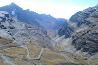 In the 1930s and 1940s, the Death Road was built by military prisoners from Paraguay to create a link between La Paz and the Jungle. Rising 3,600m in 64km, this road is only 3.2m wide at some points (just wide enough for a truck) and was the only route to the jungle until 2006. The road gets it's well deserved name from the 200-300 people who died on it and the over 26 vehicles lost over the edge, every year the road has been open ... more than died in the war between Paraguay and Bolivia. The reason for these deaths, aside from the narrow road, is that at some points, there is a 600m drop over the edge, straight down. The only bright side to biking it these days is that the road is closed to public transport (due to construction work on the new road, it will be open to public transport for a month in the upcoming weeks).
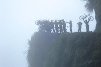 Because of the reputation of this road, we opted to travel with one of the more reputable companies, Downhill Madness. This company supplied us with dual suspension bikes, full face helmets and a guide who worked as a paramedic in Germany and is well versed in high mountain rescues. Since there is a 3,600m vertical drop over the 64km of road, peddling was not that important as you were able to reach breakneck speeds thanks to gravity. The first half of the trip is on a wide paved road that serves as the alternative for public transport. It isn't until you get on the gravel road that the trip gets scary ... and I mean scary. This road had a lot of loose gravel and the guide stopped every 5-10 minutes to do a head count to make sure no one went off the edge (one of our guys did, but luckily it wasn't a dangerous section of the road and he got back on the bike unharmed). At each stop, in case we weren't scared enough, our guide would tell the story of the person for whom the corner is named.
It seemed every corner had a story about someone dying, and to be honest, most of the accidents are preventable. One such story tells about two guys who were joking around on the trail, bumping into each other and punching each other as they rode, that is until they hit too hard and one went into the wall and the other went off the cliff. Another is about a woman who was backing her bike up to make room for a truck going by, only to find she was too close to the cliff and over she went. We saw a car over the edge of the cliff that went there because the driver was drunk (the trip used to take up to 5 days for heavy trucks, so the drivers would chew coco leaves, drink alcohol and smoke to stay awake). We saw the site of the worst accident (100 people died on a bus that went over the edge), the last death (they think it was due to a heart attack ... no wonder given the height of the cliff). Our driver's only accident on the road was when he was hit off the side ... the car is still there. Neediess to say, these stories definitely made sure our adrenalin was pumping.
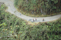 Now if the stories of the deaths and the height of the cliffs and the narrow road wasn't enough to scare you, there was even more to frighten you. First of all, because the road was so narrow, they changed the rules of the road so you are driving on the left side. This makes perfect sense, especially since the driver sits on the left and can look out his window to make sure he is still on the road when a truck passes. The problem is that when you are biking, the cliff is on the left side and the safe rock wall is on the right .... which side do you want to bike on? Next you have nice loose gravel and lots of rocks. When you turn left, you're scared of over-steering and going off the edge. When you turn right, you're scared the gravel will be too loose and you will go over the side. When there are no turns, you have to keep avoiding the rocks in the middle of the road to make sure you don't loose control of your bike (I hit a few of them on the way down, and let me tell you, you know you're alive when you hit them). Personally, I had my own unique issue to worry about, a guy who was showing off his mountain biking skills to his girlfriend, going very close to the edge, travelling fast, jumping and skidding his tires ... and he didn't feel he needed to give the person in front (me) 5m of space incase something happened. I seriously thought he was goign to hit my back wheel a few times and send me over the edge.
Now it isn't all doom and gloom on this road. Because you are on the edge of the Andes and the jungle, the view is remarkable. We started out with a beautiful, but cold day at the top (over 4,500m) then drifted into some cloud cover and then exited in the jungle. Rather breathtaking scenery all around us. We even got to cross two rivers (at the bottom where it was flat) by riding through them. At the end we had a nice lunch at a hotel in the jungle (even if the hotel was at the top of the hill in the town, and the road was so steep that the support vehicle couldn't get up it with us inside). Then we got to finish the day off by squeezing in a 15 passenger van (all 12 of us) and going on our lovely 4 hour drive back to La Paz for the night.
 In the 1930s and 1940s, the Death Road was built by military prisoners from Paraguay to create a link between La Paz and the Jungle. Rising 3,600m in 64km, this road is only 3.2m wide at some points (just wide enough for a truck) and was the only route to the jungle until 2006. The road gets it's well deserved name from the 200-300 people who died on it and the over 26 vehicles lost over the edge, every year the road has been open ... more than died in the war between Paraguay and Bolivia. The reason for these deaths, aside from the narrow road, is that at some points, there is a 600m drop over the edge, straight down. The only bright side to biking it these days is that the road is closed to public transport (due to construction work on the new road, it will be open to public transport for a month in the upcoming weeks).
  Because of the reputation of this road, we opted to travel with one of the more reputable companies, Downhill Madness. This company supplied us with dual suspension bikes, full face helmets and a guide who worked as a paramedic in Germany and is well versed in high mountain rescues. Since there is a 3,600m vertical drop over the 64km of road, peddling was not that important as you were able to reach breakneck speeds thanks to gravity. The first half of the trip is on a wide paved road that serves as the alternative for public transport. It isn't until you get on the gravel road that the trip gets scary ... and I mean scary. This road had a lot of loose gravel and the guide stopped every 5-10 minutes to do a head count to make sure no one went off the edge (one of our guys did, but luckily it wasn't a dangerous section of the road and he got back on the bike unharmed). At each stop, in case we weren't scared enough, our guide would tell the story of the person for whom the corner is named.
 It seemed every corner had a story about someone dying, and to be honest, most of the accidents are preventable. One such story tells about two guys who were joking around on the trail, bumping into each other and punching each other as they rode, that is until they hit too hard and one went into the wall and the other went off the cliff. Another is about a woman who was backing her bike up to make room for a truck going by, only to find she was too close to the cliff and over she went. We saw a car over the edge of the cliff that went there because the driver was drunk (the trip used to take up to 5 days for heavy trucks, so the drivers would chew coco leaves, drink alcohol and smoke to stay awake). We saw the site of the worst accident (100 people died on a bus that went over the edge), the last death (they think it was due to a heart attack ... no wonder given the height of the cliff). Our driver's only accident on the road was when he was hit off the side ... the car is still there. Neediess to say, these stories definitely made sure our adrenalin was pumping.
 Now if the stories of the deaths and the height of the cliffs and the narrow road wasn't enough to scare you, there was even more to frighten you. First of all, because the road was so narrow, they changed the rules of the road so you are driving on the left side. This makes perfect sense, especially since the driver sits on the left and can look out his window to make sure he is still on the road when a truck passes. The problem is that when you are biking, the cliff is on the left side and the safe rock wall is on the right .... which side do you want to bike on? Next you have nice loose gravel and lots of rocks. When you turn left, you're scared of over-steering and going off the edge. When you turn right, you're scared the gravel will be too loose and you will go over the side. When there are no turns, you have to keep avoiding the rocks in the middle of the road to make sure you don't loose control of your bike (I hit a few of them on the way down, and let me tell you, you know you're alive when you hit them). Personally, I had my own unique issue to worry about, a guy who was showing off his mountain biking skills to his girlfriend, going very close to the edge, travelling fast, jumping and skidding his tires ... and he didn't feel he needed to give the person in front (me) 5m of space incase something happened. I seriously thought he was goign to hit my back wheel a few times and send me over the edge.
Now it isn't all doom and gloom on this road. Because you are on the edge of the Andes and the jungle, the view is remarkable. We started out with a beautiful, but cold day at the top (over 4,500m) then drifted into some cloud cover and then exited in the jungle. Rather breathtaking scenery all around us. We even got to cross two rivers (at the bottom where it was flat) by riding through them. At the end we had a nice lunch at a hotel in the jungle (even if the hotel was at the top of the hill in the town, and the road was so steep that the support vehicle couldn't get up it with us inside). Then we got to finish the day off by squeezing in a 15 passenger van (all 12 of us) and going on our lovely 4 hour drive back to La Paz for the night.
Friday, May 9, 2008
May 9 - Tiwanaku
Today was our last day of the GAP tour, but sadly most people didn't show up for the trip and instead opted to stay in La Paz and partake in a city tour. It was unfortunate that the group felt this excursion was unnecessary as they missed an interesting day, especially since most of them still had another two days in La Paz.
The Tiwanaku site is located about 1.5 hours outside of La Paz (main reason for most people not coming) and was the spiritual and political centre of the Tiwanaku culture, a pre Inca civilization that dated from 600BC to 700AD. With things still being discovered at this site, it was granted UNESCO world heritage status only a few years ago.
 Our tour started with two different museums at the Tiwanaku site. The first of these museums housed only a statue and reed boat. The statue was the Megalito Bennetto Pachamama, the source of most of our knowledge of the Tiwanaku culture. This massive statue was carved in the resemblance of Pachamama (Quechwa for mother earth) and is covered with different symbols that have been interpreted to show the 4 seasons, 365 days of the year and symbols for the solstice and equinox. As we soon learned, this is all speculative and most of the information just gets sketchy. There was also a reed boat that was constructed to help show how the rocks had been moved across Lake Titicaca to this site. The plan is to move all the main statues and sun gate to this museum, away from the archeological site, so as to better preserve them.
The second museum was a little better, but was more like a grade 5 science project than a serious archeological museum. This museum’s focus was on the pottery found in and around the archeological site. The guide did her best to explain the findings, making some very bold claims including how some of the pottery represents Spaniards (even though they didn’t arrive for another 1,000 years after the fall of the culture) and Mongolians. As we had seen better museums of indigenous artifacts, this didn’t interest us much, and the bold claims just started to annoy us after a while.
 The reason for these bold, unsubstantiated claims is that only 1% of the site has been excavated. The Bolivian government only needs about $10 million to fully excavate the site, but as of now have only received $1 million in funding. As such, our next stop on the tour, the actual archeological site, was an active site where discoveries were being made and excavated while we were there. While walking around you could see the remains of the religious pyramid that quickly faded into the dirt of the hill from which it is being excavated (they told us the culture built it and then buried it before abandoning the site ... yet again, a little far fetched, especially since Machu Picchu was naturally buried under dirt after only 300 years). There were also some bones being carefully excavated from the base of the pyramid.
The site is rather unimpressive at this time, but part of that has to do with having already visited the Inca ruins in the Sacred Valley and Machu Picchu. Even though it wsa fascinating to watch them actually excavate a new archeological site, it was more interesting to hear the guide’s interpretations of the ruins and how she presented them as fact (keep in mind only 1% has been uncovered so you can’t make assumptions ... it’s kind of like visiting only the subway of New York and determining that the entire United States is built underground). Some of her assumptions were based on the Sun Gate where she concluded the Tiwanaku culture had determined there were 24 hours in a day, 7 days in a week, 12 months in a year, and 365 days in a year. Very interesting that they had invented the exact same calendar as the Europeans, especially since the closest culture to have developed a calendar were the Mayans, and they determined there were 20 months in a year (She did say that maybe their culture believed in 20 months, as behind the sun gate there was a wall with 10 large stones in it. She said they moved an idol from one stone to another to mark each passing month).
 Her assumptions didn’t end there. The last site we visited, a sunken temple, she claimed was a place to worship the afterlife. She believed that the pyramid was to worship the sun and that above us, the sun temple (at ground level) was to worship the earth and the life we currently are living (forget that she also told us this was the astronomical observatory) and the sunken temple was for worshiping the afterlife (as you can see, they need to do some more excavation). The sunken temple though was incredibly interesting as its walls were adorned with over 100 carved heads sticking out of the wall. All in all this made for the most interesting part of the whole archeological site.
After lunch, we headed back to La Paz for some shopping around the hotel in the artisan markets, and a final dinner with the rest of our group at a lovely French restaurant. Looking back, this was a great group to travel with and the trip offered a wonderful overview of the Inca Empire.
The Tiwanaku site is located about 1.5 hours outside of La Paz (main reason for most people not coming) and was the spiritual and political centre of the Tiwanaku culture, a pre Inca civilization that dated from 600BC to 700AD. With things still being discovered at this site, it was granted UNESCO world heritage status only a few years ago.
 Our tour started with two different museums at the Tiwanaku site. The first of these museums housed only a statue and reed boat. The statue was the Megalito Bennetto Pachamama, the source of most of our knowledge of the Tiwanaku culture. This massive statue was carved in the resemblance of Pachamama (Quechwa for mother earth) and is covered with different symbols that have been interpreted to show the 4 seasons, 365 days of the year and symbols for the solstice and equinox. As we soon learned, this is all speculative and most of the information just gets sketchy. There was also a reed boat that was constructed to help show how the rocks had been moved across Lake Titicaca to this site. The plan is to move all the main statues and sun gate to this museum, away from the archeological site, so as to better preserve them.
The second museum was a little better, but was more like a grade 5 science project than a serious archeological museum. This museum’s focus was on the pottery found in and around the archeological site. The guide did her best to explain the findings, making some very bold claims including how some of the pottery represents Spaniards (even though they didn’t arrive for another 1,000 years after the fall of the culture) and Mongolians. As we had seen better museums of indigenous artifacts, this didn’t interest us much, and the bold claims just started to annoy us after a while.
 The reason for these bold, unsubstantiated claims is that only 1% of the site has been excavated. The Bolivian government only needs about $10 million to fully excavate the site, but as of now have only received $1 million in funding. As such, our next stop on the tour, the actual archeological site, was an active site where discoveries were being made and excavated while we were there. While walking around you could see the remains of the religious pyramid that quickly faded into the dirt of the hill from which it is being excavated (they told us the culture built it and then buried it before abandoning the site ... yet again, a little far fetched, especially since Machu Picchu was naturally buried under dirt after only 300 years). There were also some bones being carefully excavated from the base of the pyramid.
 The site is rather unimpressive at this time, but part of that has to do with having already visited the Inca ruins in the Sacred Valley and Machu Picchu. Even though it wsa fascinating to watch them actually excavate a new archeological site, it was more interesting to hear the guide’s interpretations of the ruins and how she presented them as fact (keep in mind only 1% has been uncovered so you can’t make assumptions ... it’s kind of like visiting only the subway of New York and determining that the entire United States is built underground). Some of her assumptions were based on the Sun Gate where she concluded the Tiwanaku culture had determined there were 24 hours in a day, 7 days in a week, 12 months in a year, and 365 days in a year. Very interesting that they had invented the exact same calendar as the Europeans, especially since the closest culture to have developed a calendar were the Mayans, and they determined there were 20 months in a year (She did say that maybe their culture believed in 20 months, as behind the sun gate there was a wall with 10 large stones in it. She said they moved an idol from one stone to another to mark each passing month).
 Her assumptions didn’t end there. The last site we visited, a sunken temple, she claimed was a place to worship the afterlife. She believed that the pyramid was to worship the sun and that above us, the sun temple (at ground level) was to worship the earth and the life we currently are living (forget that she also told us this was the astronomical observatory) and the sunken temple was for worshiping the afterlife (as you can see, they need to do some more excavation). The sunken temple though was incredibly interesting as its walls were adorned with over 100 carved heads sticking out of the wall. All in all this made for the most interesting part of the whole archeological site.
After lunch, we headed back to La Paz for some shopping around the hotel in the artisan markets, and a final dinner with the rest of our group at a lovely French restaurant. Looking back, this was a great group to travel with and the trip offered a wonderful overview of the Inca Empire.
Subscribe to:
Posts (Atom)
