We started our four day trek of the Inca trail by driving an hour to kilometer 82 (the starting points are measured by the train track) near the town of Chilca. Here we met our porters, had our first of many group pictures and got our passports stamped to get onto the trail (the Canadian government is going to love that one). At around 10:00 we started our hike up the mountain with the eventual destination of Machu Picchu.
The first two days of the Inca trail, as it has come to be known, actually isn't the original trail. As parts of the trail are still being uncovered, when the trail was opened, they created a connecting trail from the train tracks to the actual Inca trail. The route we took is the most common route and stretches for a total of 43km with an altitude reaching 4,200m and descending to approximately 2,400m at Machu Picchu (a lower altitude than our starting point). For most tourists, this hike takes 4 days, but for the porters it can be done much faster. Our guide for instance did it in one day, and the record is 3 hours and 45 minutes. Considering this is up and down, consisting of thousands of steps and for a distance of a marathon, it is better than impressive (we actually met the porter who holds the record, a local hero since he beat world renowned marathon runners ... good for a local boy in sandals). The average tourist walks only 11km a day, but due to permits, we happened to get the longest hikes, where on one day we actually covered the distance most groups cover in two days.
The first day of hiking was mostly through an open landscape. As it is still quite close to the train tracks, there are shops along the way to pick up some water, and there are lots of local people going about their daily business, mostly farming. For most people the first day is a gentle climb and they all spend the night at the base of what is known as "Dead Woman's Pass". Luckily for us, we still had another two hours of climbing, almost straight up to our campsite at Yuncachimpa, an elevation of 3,300m (after starting at 2,500m). Even though the hike was no more than 12km on the first day, it took us almost the entire day as we stopped along the way to look at various ruins and take many rests. The main ruin we visited today was Patallacta, a semi-circle town built at the base of a mountain that supplied most of the food for Machu Picchu.
The next day we were to have quite an early start as it was going to be our longest day, covering about 15km over the two main mountain passes, Dead Woman's Pass at 4,200m then Runkuraky pass at 3,900m. It shouldn't be too bad except that we had to go down a valley that descended to almost 3,100m. Needless to say it took Sandy and me all day and we didn't arrive at camp until after dark. The trek up to Dead Woman's Pass was mostly through the tundra, but the way the trail was structured, we kept seeing what we thought was the top. Until we made it there did we see that we actually had another 500m to go. After about 6 of these false peaks, and 3 hours of hiking uphill, we reached Dead Woman's Pass. From there it was another 2 hours of going downhill. This was the point at which Sandy started to have problems with her knees which didn't stop bothering her until she went home to Canada.
At the bottom of the valley is the town of Paq'aymayo where we had lunch (and where most people spend the night). The nice thing about the Inca trail is you can't go on it without a tour group and porters. Since they are unionized, there is only a limited amount of weight that they can carry (about 24kg) and you have the carry the rest (my bag was about 6kg ... not much at sea level, but a lot at 4,200m). There is also a formula to calculate the number of porters per group, so in order to make them all useful; they bring all the luxuries of home. By the time you reach the lunch stop, they have set out individual buckets for you to wash your hands and set up the cooking and dining tent (complete with a tablecloth). It makes the entire journey quite luxurious. In order for them to get there so far before us, they actually run along the trail. The hardest obstacle you have on the trail are the porters running by. Sadly today, since those of us in the back took so long, the rest of the group had eaten lunch before we arrived and were heading out when we got there.
After lunch we started our second pass .... about 600m up followed by 600m down - a nice way to finish our day. Yet again we happened upon lots of false peaks, one of which we were so sure was the top, we spent all our energy getting there and had to rest for quite a while since there was still another 30 mintues of hiking left to get to the top. Along the way we happened upon a second set of ruins, Runkurakay. As we didn't have the main guide with us (but we had Marcella ... God bless her. She was great to hike with, even if Sandy did completly freak her out when she had an asthma attack on Dead Woman's Pass) I made up a story that this was a bathroom along the trail and the women had more stalls than the men's bathroom. It turns out I wasn't far off. The Incas had built little towns and check points along the way for those hiking the Inca trail (we met up with the real trail just before lunch) to provide shelter, food and a washroom. This was one of those checkpoints. Not to be outdone, Jim actually found a mountain that looked like an Inca king over looking the valley, and this was probably the most likely of all the stories we heard about carvings in the hills.
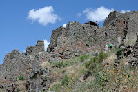
We reached the top of the second summit just before sunset, and as we still had about 2 hours of hiking left for us, Freddy (the main guide) sent two porters back to help us and bring us some flashlights. God bless him since there were a lot of steps that we didn't see in the dark. It actually made for an interesting hike. You could randomly turn your head and right beside you was an old Inca fortress which if you didn't turn your head at the right time you would have missed. Who knows what else we missed that night.
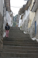
The third day was supposed to be our very easy day, but I think for Sandy it was the hardest day. Most of the route was downhill as we only had to go up about 200m in the entire day. It was also only a 5km hike, so we should have been done at around 2 in the afternoon. Well, Sandy and I did make that 2:00 deadline, but sadly for Sandy, there were over 3,000 steps down that we had to make that day. I think it took her about twice as long as everyone else as each step hurt like hell. Yet again Marcella was with us and helped us go along.
The third day was also probably the most beautiful day as we were hiking through the cloud forest the entire day, which made for some lovely scenery. The steps also made for an interesting addition to the trail as some of them were actually carved into the rocks. It's hard to imagine that in 100 years the Incas built tens of thousands of kilometers of trail in this fashion. We reached the campsite at around 2:00 in time for lunch, a shower (yes, the last site has a bar, restaurant, and shower facilities) and a well deserved rest. Before dinner I headed over to Wiñaywayna to see probably the most beautiful example of Inca construction. The hike was quite easy, but I made the mistake of going down the steps to the bottom of the town to see what was at the bottom ... this meant I had to come back up again.
The next morning we had a very early start to the day, leaving at around 4:00am (the bar closed at 10:00pm the night before ... probably the only one that closes that early in the world) so that we could do our last 3 hour hike to Machu Picchu and reach the sun gate in time to watch the sunrise. As it had rained the night before, the sun gate was quite the disappointment as it was quite foggy and you couldn't see anything. The only saving grace were the last 52 steps that were straight up ... you actually had to climb on all fours in order to reach the top of the hill.
From the sun gate it was a gentle walk down the trail where we started to see the day's tourists ... they were walking up to the sun gate in clean hiking boots, Coach handbags and lovely designer walking sticks. Most were very impressed that we had just hiked the entire trail, and to be honest, we felt like they didn't deserve to be there. When we reached Machu Picchu it was still quite foggy, so we went to the entrance to the site to have a drink and wait for the fog to clear. This is where Sandy had real problems. If her knee didn't hurt her before, on this last set of steps she could feel the tendons actually tearing in her knees. When we got to the bottom a few of us found ice for her knee. Sadly for her, this meant she wouldn't be as maneuverable when we visited the actual site. She missed out on the tour, but still managed to see quite a bit of the site at her own pace (I think she only missed the guard house at the top of the hill).
Once the fog lifted we headed out with 3 hours to explore Machu Picchu. This has to be one of the most awe inspiring sites in the world and it can't be described in words. The massive expanse of the site is as incredible as you would imagine. It is an entire town with religious centres, residences, agricultural centre, guard house and other things we could not identify. This rivals any other ruins in the world in shear size and you can't possibly explore it all in three hours without skipping over things or not giving it the time it deserves. Definitely it was the best way to finish the hike.
After we had finished exploring the site, we headed back to Cusco by train and bus. We all were quite tired, but all felt it was the most worthwhile part of our trip.
Saturday, May 3, 2008
Tuesday, April 29, 2008
Apr. 29 - The Sacred Valley
Today we made our way to the starting point of the Inca trail. In order to get there we had to go through the Sacred Valley; a stretch of valley full of fertile soil and Inca ruins.
 Our first stop on the way was at Ccaccaccollo, a community which GAP has sponsored as part of its Planeterra initiative. GAP located this town and selected it as a place where it felt they could help the community grow. They hire most of the men in this community as guides on the Inca trail, and helped train two women in traditional weaving practices. These two women then went back to Ccaccaccollo to help train the rest of the women and now have a thriving traditional weaving business. GAP continues to help this community by bringing their tour groups here to buy the merchandise the town produces. As part of this visit, the women dress up in the traditional costumes and provide a demonstration on the whole weaving process from the different types of wool, dying, spinning the wool and actually making the final products. It turns out that we are paying about 50 soles (about $20) for something that the women will spend a month making, it hardly seems fair and you definitely don’t feel like bargaining after hearing that. Following the presentation we were given a little time to talk to the women and purchase some of the items, the only problem was that you would then have to carry these items along the Inca trail and our bags were already overweight.
 From Ccaccaccollo we headed over to Pisac, one of the best examples of the Inca agricultural terraces. In order to help increase the agricultural production, the Incas built thousands of agricultural terraces that can be seen throughout the Sacred Valley. Pisac in particular were the best built and took most of the thought. They built them on the east side of the mountain so as to better soak up the morning sunlight and remain warm throughout the day, thus increasing productivity. They also found the soil at the bottom of the valley was more fertile, and thus carried it up the hill to increase production. But after a few years they noticed that most of the nutrients had been taken out of the soil, so back to the valley floor (maybe a 10km hike) to get more soil to fill in the terraces. The amount of work here would have been incredible, but it worked.
 At the top of the hill at Pisac is a ceremonial site where the Incas worshiped their four main gods: Earth, Wind, Sun and Water. It was also an important burial site at the top of the hill, so situated that the dead would be closer to the Sun god and reincarnation. When you look at the hill where the grave yard is, there are hundreds of holes where the Spanish broke in to rob the graves of gold, but found nothing. This is because this particular grave site was for the commoners, therefore no gold. Leaders, rich and holy people were buried in other, more ornate locations in the fetal position, unlike the commoners who were buried flat on their back (the thought here is that the leaders were going to be born again, and the commoners were going to just have to get back to work).
After the ruins, we headed down to the town of Pisac to partake in their market day. With only 15 minutes to explore the market, there was no way to grasp the entire size of the market, although it wasn’t as big as Otavalo’s market in Ecuador. Once back in the bus we made our way to a small hacienda where we had a lovely lunch before our last jaunt in the bus to Ollantaytambo, our rest stop for the night.
 Before we settled down for a rest at Ollantaytambo, we went to the ruins located in the middle of town, a lovely hike up many terraces, to learn about the purpose of the town, in particular its importance as one of the last stands of the Incas against the Spanish, which the Incas actually won. This site was not only a military site, but it is an example of Inca ingenuity. First off, the town itself still maintained the Inca style of construction, which included rivers of water going through the street so as to supply the town with water. What happened when they came to the main street in the town was move the water underground so that the siphon power would force the water back up on the other side of the main street and keep flowing. If this isn’t impressive enough, they had to find a way to supply their grain shed with water way up on the hill. They did this through the same siphon technique, but using a water source high enough to push the water up to that level .... from 10km away. The grain shed was high on the hill for a specific reason as well. There was wind up there to keep everything cool and refrigerated so that the food didn’t spoil for the town people.
 Here, Mario (our guide for the Sacred Valley) told us about how the Incas got the large rocks up the hill (some weighing more than 20 tons). He said they built an incline, much like the Egyptians. Unlike the Egyptians, they didn’t use any wheels to bring the rocks up because if they broke, the rock would fly down the hill and they would have to start over again. Instead they developed a compound that they would spread along the road across which rocks moved (the quarry was at least 20km away ... in some places it was as much as 40km away, and they did all the carving and shaping of the rocks there) and when the rock stopped, the pressure of the rock would turn this compound into glue, and once they started moving again it would unstick and slide easily. Remarkably, considering the rocks were carved so far away, they fit together so closely that they didn’t need any mortar between the rocks, and you can’t slide a piece of paper between the rocks if you wanted to. They even knew how to arrange the rocks (slanted backwards and off centre from each other) to prevent issues with earthquakes. All in all, this society was incredibly advanced.
Monday, April 28, 2008
Apr. 27-28 - Cuscotopia
Today we had an early departure flight to Cusco. As this was Manuel's first trip as a guide, things went a little slower than planed. In the end we did manage to get our flight to Cusco with very little time to spare (it was better than a 24 hour bus ride). One nice thing about the flight is that it was a beautiful day over the Andes, so our hour flight gave us some remarkable views of the Andes and it's green hills and snow capped mountains.
 Once we were in Cusco, most of the people on our trip got their first taste of altitude sickness. For most this just meant they were a little light headed, but we were all rather surprised to find that there was a stand at the airport selling bottles of oxygen for the tourists. Cusco might be high, but it isn't so high that you would require extra oxygen. We did find the hotel had their own oxygen tank, and they were serving Coca Tea like it was going out of fashion (everywhere you went they were selling either the tea to drink or the leaves to chew on). Due to the altitude, most of the people in our trip slept all afternoon after we had lunch.
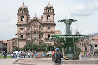
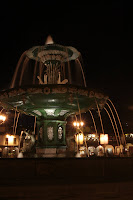 After our lovely nap (part of my daily ritual now....probably will have to do something about that when I start working again) we took a walk around the Plaza de Armas, taking pictures of the buildings in the city, and then took a short stroll around some of the blocks around the city centre, just trying to help acclimatize faster. To give you an idea how small the city centre is, we happened to bump into everyone in our group during our hour outing.
As we found out quickly, Manuel knew all the coolest places to eat dinner and we were never disipointed. Tonight we happened upon a small Peruvian diner that allowed me to try Alpaca meat. I recommend to anyone to try alpaca, it tastes very close to beef and was remarkable. But due to the altitude (a very good excuse if you are ever looking for one) we turned in early so as to conserve our energy.
 The next morning we got up when we were ready and found out over breakfast that there was not enough room for all of us to go on the ATV ride, so Sandy and I opted to go horseback riding instead. While we were waiting for our tour to start, we walked around the town looking for equipment we would need for our upcoming Inca Trail hike (walking poles, warm clothes, hats, etc.) and explored the town looking at all the craft shops. One of interest was an art shop where we spent about an hour talking to the owners about Peruvian art, the artists and how their styles changed. In the end we bought a lovely piece of art from the lady, making her first sale at the art gallery.
While walking around we happened to bump into Manuel who informed us he wanted to talk to everyone who was going on the ATV tour at 1. So we headed back to the hotel, and we decided to go in two different groups. As Sandy and I were more than willing to back out this morning, Manuel made sure we went in the first group. We headed out to a restaurant for a quick lunch, and through some confusion, we ended up eating with a GAP group that just finished the Inca Trail and gave us a quick description of the trip. It made us very excited to start hiking the trail ... especially since they told us the food was great.
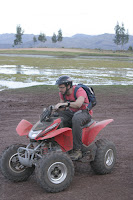 The ATV ride was tons of fun. We started off (Nick, Anastasia, Nina, Nnenna and Sandy) with some lessons on how to ride the 4-wheelers and got a safety lesson before we headed out on our ride. The first 10 minutes of the ride were through the streets of Cusco before we managed to get off road through the mountains around Cusco. Once we went off the main streets we were blessed with beautiful views of the mountains, travelling through farm country, adobe brick houses and a lovely lake. On the ride though, Nnenna had a few problems. One time she went off the road and got the ATV stuck. The second time she managed to sharply turn the ATV and flipped the bike. Luckily she was spared any injury. But the most nerve-racking part of the ride was coming back where we had to drive through the city during rush hour. There's nothing like flying through the streets at night praying that you don't get run over.
Once back at the hotel we started our briefing for our Inca trail trek. We were given a list of equipment and bag to put everything in, but also given a 6kg limit. The problem is that when we started packing, we couldn't fit everything in our bag, and when we finally did get it in we were overweight. There is no way you can get everything they tell you to bring in the bag. We had to weigh it three times before everything fit. After Freddy (our guide for the Inca Trail) had finished his briefing, everyone was ready for the 4 day Inca Trail hike.
 Once we were in Cusco, most of the people on our trip got their first taste of altitude sickness. For most this just meant they were a little light headed, but we were all rather surprised to find that there was a stand at the airport selling bottles of oxygen for the tourists. Cusco might be high, but it isn't so high that you would require extra oxygen. We did find the hotel had their own oxygen tank, and they were serving Coca Tea like it was going out of fashion (everywhere you went they were selling either the tea to drink or the leaves to chew on). Due to the altitude, most of the people in our trip slept all afternoon after we had lunch.
 After our lovely nap (part of my daily ritual now....probably will have to do something about that when I start working again) we took a walk around the Plaza de Armas, taking pictures of the buildings in the city, and then took a short stroll around some of the blocks around the city centre, just trying to help acclimatize faster. To give you an idea how small the city centre is, we happened to bump into everyone in our group during our hour outing.
As we found out quickly, Manuel knew all the coolest places to eat dinner and we were never disipointed. Tonight we happened upon a small Peruvian diner that allowed me to try Alpaca meat. I recommend to anyone to try alpaca, it tastes very close to beef and was remarkable. But due to the altitude (a very good excuse if you are ever looking for one) we turned in early so as to conserve our energy.
 The next morning we got up when we were ready and found out over breakfast that there was not enough room for all of us to go on the ATV ride, so Sandy and I opted to go horseback riding instead. While we were waiting for our tour to start, we walked around the town looking for equipment we would need for our upcoming Inca Trail hike (walking poles, warm clothes, hats, etc.) and explored the town looking at all the craft shops. One of interest was an art shop where we spent about an hour talking to the owners about Peruvian art, the artists and how their styles changed. In the end we bought a lovely piece of art from the lady, making her first sale at the art gallery.
While walking around we happened to bump into Manuel who informed us he wanted to talk to everyone who was going on the ATV tour at 1. So we headed back to the hotel, and we decided to go in two different groups. As Sandy and I were more than willing to back out this morning, Manuel made sure we went in the first group. We headed out to a restaurant for a quick lunch, and through some confusion, we ended up eating with a GAP group that just finished the Inca Trail and gave us a quick description of the trip. It made us very excited to start hiking the trail ... especially since they told us the food was great.
 The ATV ride was tons of fun. We started off (Nick, Anastasia, Nina, Nnenna and Sandy) with some lessons on how to ride the 4-wheelers and got a safety lesson before we headed out on our ride. The first 10 minutes of the ride were through the streets of Cusco before we managed to get off road through the mountains around Cusco. Once we went off the main streets we were blessed with beautiful views of the mountains, travelling through farm country, adobe brick houses and a lovely lake. On the ride though, Nnenna had a few problems. One time she went off the road and got the ATV stuck. The second time she managed to sharply turn the ATV and flipped the bike. Luckily she was spared any injury. But the most nerve-racking part of the ride was coming back where we had to drive through the city during rush hour. There's nothing like flying through the streets at night praying that you don't get run over.
Once back at the hotel we started our briefing for our Inca trail trek. We were given a list of equipment and bag to put everything in, but also given a 6kg limit. The problem is that when we started packing, we couldn't fit everything in our bag, and when we finally did get it in we were overweight. There is no way you can get everything they tell you to bring in the bag. We had to weigh it three times before everything fit. After Freddy (our guide for the Inca Trail) had finished his briefing, everyone was ready for the 4 day Inca Trail hike.
Subscribe to:
Posts (Atom)
